IGN map

IGN map

Aerial photos / IGN

Slope map (IGN map)

Map 1950 / IGN

Staff map (1820-1866)

Open Street Map

Through fields and hedgerows, this itinerary takes you to the springs of Caudesaygues, a stream with "warm waters". Espinas grew up at the foot of a feudal tower, where inhabitants could shelter their belongings in case of danger. Some elements of this tower, known as "la murette", remain in the center of the village. Every year, the traditional haymaking festival takes place, organized by the village's festival committees. The village is brought to life by life-size straw figures representing the trades our peasants practiced at the time of haymaking, all dressed in authentic period clothing. Route with 55% of road.
You'll discover the terrefort, a transitional region between the Causse and the granite soils of the Massif Central. The landscape is hilly and the clay-covered soil is richer and deeper than on the Causse. It is consequently more cultivated. This is an agricultural landscape where meadows and fields alternate. On the steepest slopes, woods of downy and pedunculate oak, ash, lime, elm and hornbeam dominate. Route with 65% of road.
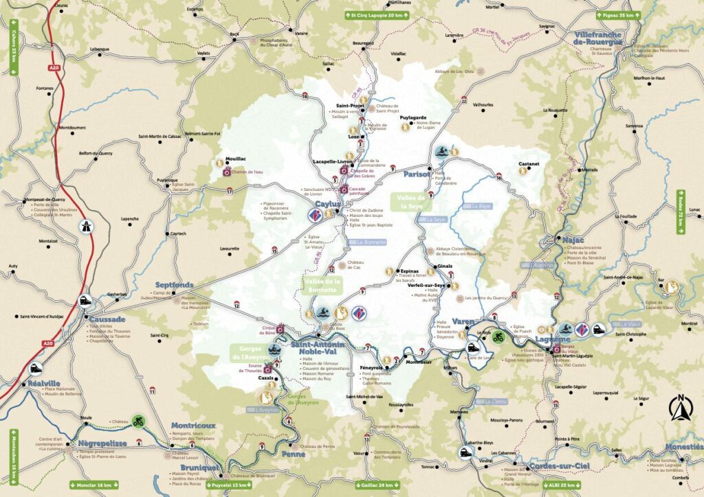
This circuit around Caylus is rich in historical heritage. Ancient Roman roads, stone crosses, dolmens and caves are just some of the vestiges that will enhance your walk in a varied natural environment. This is a mountain bike trail with a slight gradient.
This hike has few road sections. However, it is long and fairly sunny, so we recommend it for good walkers. The fauna is rich and you may even spot a roe deer or the large green lizard that populates the Causse. An ideal hike for discovering the flora of the Causse. You'll alternate between meadows, moors and undergrowth. In the coombs preceding Gagne-Po (Ganha pan: breadwinner), the path winds under boxwood arbors, offering a refreshing moment for summer hikers. In Caylus, the Place de la Halle, with the facades and roofs of the buildings lining it, was listed as an Inscribed Site. La Halle became a Monument Historique on February 16, 1900. The structure and shape of its pillars suggest that the Halle dates from the late 15th and early 16th centuries. Built in 1505, it was originally located on the opposite side of the square, with just fourteen pillars. It was moved and enlarged in 1905.
Route with 20% of road.
This walk allows you to appreciate the diversity of the Causse: meadows, juniper heaths and oak woods follow one another. Animals can often be seen. Several noteworthy hamlets are on this route (La Salle, Burguet and Genebrières). At Pech Poujol (potzol: little well), there's a remarkable viewpoint over the Causse, with the presence of a windmill. This trail is unusual in that it features several wells, one of the richest features of the Causse. There are both roofed wells (to supply the local population) and open wells (to water livestock). Discover the Genebrière mare-lavoir: water was and remains a precious resource on the Causse. That's why people came to the same place to water their livestock and wash their clothes. The V-shaped slabs of sloping stone were used to beat the linen. They are known as «lavoir-papillon» (butterfly wash) because they resemble the wings of this insect. (Source APICQ) Route with 30 % of road.
The priory of Saint-Symphorien is located partly in Caylus (the choir) and partly in Puylaroque (the nave). The present-day church of Saint-Symphorien dates back to the 15th century. It was built on the site of an earlier church destroyed in the Hundred Years« War. The first church was built in the 12th-13th centuries. It was a former priory of the Cahors diocese. According to tradition, the church was founded in the early 11th century by the Knights of the Order of the Temple. This secluded building overlooks the Sietges stream. A so-called »miraculous« fountain springs up between the priory and the cemetery. It was said to have curative properties against blindness and rickets in children. The name Caylus derives from castellucium, meaning »little castle". Today, Caylus offers visitors the pleasure of its landscapes and a treasure trove of Gothic architecture, including the town houses, the Gauléjac pavilion, the Saint-Jean-Baptiste church with its monumental Christ carved from an abalone trunk by Ossip Zadkine, one of the undisputed masters of contemporary sculpture, and the former priory of Saint-Symphorien. Route with 20%.
IGN map
Aerial photos / IGN
Slope map (IGN map)
Map 1950 / IGN
Staff map (1820-1866)
Open Street Map
The otter has repopulated the northern part of the Aveyron and is beginning to re-establish itself further south. With a great deal of patience and luck (the otter's activity is mainly nocturnal), it can be observed. It has an elongated, streamlined dark brown body, sometimes adorned with small white spots under the throat. Along the way, you'll pass the Moulin des Ondes, whose hydraulic energy provides 250 kwh of power (annual average), and can supply around 42 homes. An interpretive trail is available on this route, accompanied by an educational booklet available from the tourist office. Route with 50%.
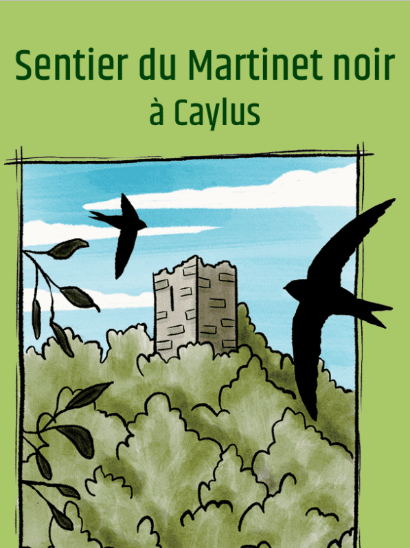
As you stroll along the trail, the Black Swift invites you to discover the Espace Naturel Sensible du cirque de Labarthe in Caylus, which bears witness to the links between nature and man, where everyone finds their place alongside nature. He's been visiting the site for centuries and will guide you on your walk! An accompanying leaflet is available on site and at the tourist office. View the discovery brochure online : www.calameo.com/read/007434666cd99ff9b7f48
This itinerary, initiated by the commune of Saint-Antonin-Noble-Val, is a nature walk created to promote the Roc d'Anglars Natura 2000 area. Signs all along the route provide information on the landscape, the various environments crossed, the flora and fauna, and human activities. A description of the trail can be found in the Saint-Antonin-Noble-Val hiking guide, on sale at the tourist office.
Eighty years after the fact, this memory trail retraces the history of the Ornano maquis, established on the Causses du Quercy a few months after the German occupation of the southern zone. It offers an opportunity to reappropriate a memory, to fight against oblivion, and to recall the relevance of the values of the Resistance, which was first and foremost a fight for principles (patriotism, freedom) and a fight by committed men imbued with a spirit of responsibility towards society and great fraternity. Here you can discover the story of the parachute drops that took place on this plateau, code-named Volcan.
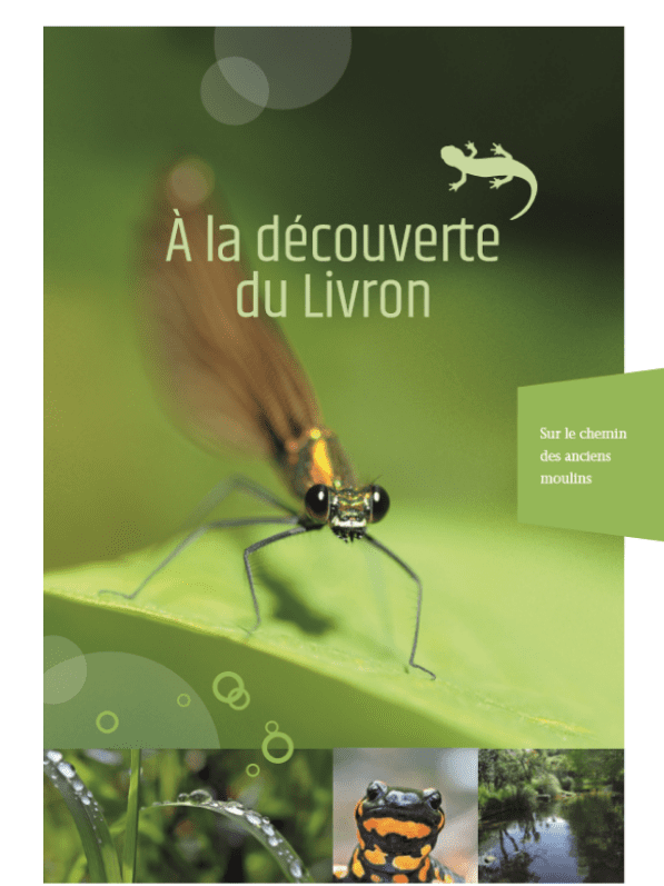
The Livron stream is unusual in many ways. Yet this little stream, just over a kilometer long, is full of curiosities. Along the way, you'll discover characteristic flora and fauna, as well as a number of picturesque features, such as the petrifying waterfall and the astonishing succession of watermills. This walk will keep you busy for 45 minutes. The route is signposted, and a discovery booklet is available free of charge from the tourist office, so keep your eyes peeled and follow the guide! Consult the discovery booklet online : www.calameo.com/read/001227374d7cf32cd38ed
This tour takes you through the Causses part of the Lacapelle-Livron commune, with its typical pigeon lofts and the history of the Caylus military camp.