
PR1 Puylagarde : Bois noir

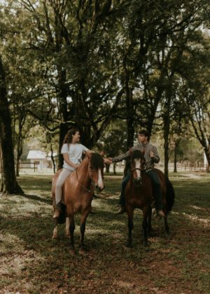
Puylagarde est le village du cheval. En effet, on y compte une station des Haras Nationaux. La Chapelle Notre-Dame de Lugan : sa construction remonte au Xe siècle, elle est caractéristique de l’architecture religieuse pré-romane (4 angles arrondis extérieurs et une nef unique suivie d’un choeur plus étroit). Ce site fut fréquenté bien avant que le village de Puylagarde ne fut créé. Au Moyen-Âge, cette chapelle était un lieu de pèlerinage. Parcours avec 30% de route.
Balisage
Circuit balisé en jaune
Stationnement
Espace Ouradou

IGN map

Aerial photos / IGN

Slope map (IGN map)

Map 1950 / IGN

Staff map (1820-1866)

Open Street Map

1
Etape 1
Départ du parking de la salle des fêtes (espace Ouradou). Dos à la salle des fêtes, se diriger à droite en direction de Lugan. Suivre la route jusqu'au pigeonnier. Virer à droite, passer devant la chapelle
Notre-Dame de Lugan qui est entourée de cèdres. Suivre la route en laissant le lavoir sur la droite.
Puylagarde
L’ancienne bastide de Puylagarde, dont il reste un château, un puits et la rue des Anglais, bénéficie de la proximité du grand axe de circulation Caussade-Villefranche- de-Rouergue. C’est la commune la plus élevée de Tarn-et-Garonne (425m).
Puylagarde est un village actif avec ses associations, ses artisans, son commerce multi-services, sa station des Haras Nationaux, son stand de tir et surtout sa salle des fêtes. D’une capacité de 400 places avec piste de danse et cuisine équipée, elle est occupée tous les week-ends et souvent en semaine pour des lotos, des mariages, des assemblées générales, des repas, des cours de gymnastique, etc.
La commune est propice à la balade à pied, à vélo et à cheval avec ses nombreux sentiers balisés. Elle possède à Lugan, sous des cèdres centenaires, une chapelle de style pré-roman aux angles arrondis, construite à la fin du Xe siècle.
2
Etape 2
A l'intersection après le lavoir, tourner à gauche pour emprunter un chemin goudronné qui se transforme en chemin herbeux. À l’intersection, suivre la voie la plus à droite. Arriver à la route et poursuivre à gauche.
Aire de pique-nique de l'espace Ouradou
Près de la salle "Espace Ouradou" à Puylagarde, cette aire de pique-nique avec tables ombragées et terrain de basket est le départ des sentiers PR1 « Bois Noir » (9 km) et PR2 « Bois Blanc » (9,5 km), praticables à pied, en VTC ou à cheval.
Située près de la salle des fêtes "Espace Ouradou" à Puylagarde, cette aire de pique-nique offre un cadre agréable avec deux tables ombragées, des poubelles, et des plantations d’arbustes. Un terrain de basket-ball est également disponible. Point de départ idéal pour deux sentiers de randonnée : le PR1 « Bois Noir » (9 km) et le PR2 « Bois Blanc » (9,5 km), accessibles à pied, en VTC ou à cheval.
3
Etape 3
Au carrefour, continuer tout droit jusqu’à la première intersection. Prendre à droite et suivre la voie
principale. À la route, tourner à droite puis immédiatement à gauche et emprunter le sentier.
Mercadiol picnic area
picnic area
Gîte Hamot
Situé en Quercy Rouergue, région réputée pour la richesse de son terroir, ses marchés locaux et ses sites classés, le gîte Hamot, conçu par son propriétaire, offre une situation et un confort exceptionnels.
Construction indépendante bioclimatique, façade en mélèze, le gite Hamot respire le calme et le confort dans un cadre de nature longée par un chemin de randonnée avec une grande terrasse à hauteur des chênes, de plain-pied avec une vaste pièce de séjour et une cuisine.
La chambre en mezzanine se situe au niveau d’une terrasse végétalisée.
Piscine naturelle (aucun produit chimique, protection antibactérienne par électrolyse cuivre/ argent) couloir de nage 14mx3m profondeur : 1m40 + espace végétalisé, à partager avec les propriétaires à 100m du gîte. Deux vélos à assistance électrique en prêt.
Une auberge au village (2 km par les bois) accessible à pied ou à vélo, propose des menus confectionnés par Caroline avec des produits locaux, un espace jeux pour les enfants et des soirées musicales.
Des fermes, producteurs locaux et marchés alentour permettent de se ravitailler en produits frais.
Les propriétaires proposent divers services en toute indépendance : diners d’arrivée, réservation d’activités, conseils.
Tout l'été, guinguette au lac de Parisot à 8 km du gîte avec marché gourmand et musique live le weekend.
4
Etape 4
Au niveau des Granges, bifurquer à droite puis de nouveau à droite. Suivre la route sur 250 m, puis
tourner à gauche vers Bénac.
5
Etape 5
A l'intersection, avant ce hameau, poursuivre sur le chemin de gauche. Après quelques mètres,
emprunter un chemin creux où les arbres forment une voûte, puis tourner à droite. Arriver à une maison en
ruine et suivre le chemin à gauche puis à droite.
6
Etape 6
Au carrefour, tourner à droite et emprunter la D33. Après environ 300 m, prendre le sentier sur la gauche. Le poursuivre jusqu’à l’intersection, s’engager à droite sur le chemin qui devient goudronné. À l’embranchement, prendre à droite en direction du village.
7
Etape 7
A l'intersection, continuer tout droit le sentier qui longe l’aire de jeux. Au carrefour du transformateur, continuer tout droit, chemin des Vignes. Après le point de vue (aire de repos), passer entre l’église et le château d’eau. Tourner à droite, longer l’église, puis tourner à gauche, rue du Château.
8
Etape 8
Au carrefour, continuer tout droit et emprunter la route qui ramène devant la salle des fêtes (Espace Ouradou), passant devant une station des Haras Nationaux.